Minespotting continued
US NASA is offering Landsat images for free, that cover the
landmass
of earth almost completely. The images are composed of two infrared
bands and visible green, in false colours, georeferenced in UTM grid.
The images may be downloaded as MrSid-formatted tiles (expect bulky 50
- 200
MB files), or as interactively chosen jpeg-windows. So far, scenes
collected in 1990 with a resolution of 28.5 m were offered. Recently
the collection was updated with images taken in year 2000, resolved to
stunning 14.25 m. The URL is accessible only temporarily (for heavy
download traffic?), so be patient, it is worth several tries.
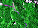
Luckily, an almost cloud-free picture of Ok Tedi Mine is
available.
It shows the pit, and the streams of dead rock and tailings from the
dumping sites north and south at the pit, shedding their load towards
Ok Tedi River. The mining town Tabubil is seen on lower right.
 click for full
picture 350 kB click for full
picture 350 kB
 Ok Tedi south of
Tabubil - the course of damage Ok Tedi south of
Tabubil - the course of damage
 Lower Ok Tedi and
Bige dredge deposit Lower Ok Tedi and
Bige dredge deposit
 Kiunga - port on Fly
River for ore concentrate Kiunga - port on Fly
River for ore concentrate
Other copper mines
 Batu Hijau, Subawa
Island, Indonesia, increasing
supplier of Affi Batu Hijau, Subawa
Island, Indonesia, increasing
supplier of Affi
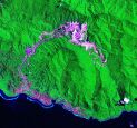
 Panguna
mine, Bougainville - resolution coarsed 25% - 57 meters. Though the
former supplier of Affi's was closed at the beginning of the
Bougainville rebellion 1989, the jungle did not recover the wounded
areas. Panguna
mine, Bougainville - resolution coarsed 25% - 57 meters. Though the
former supplier of Affi's was closed at the beginning of the
Bougainville rebellion 1989, the jungle did not recover the wounded
areas.
 Freeport, West
Papua, 1990, resolution 114 m. The mine
itself covered by clouds. Freeport, West
Papua, 1990, resolution 114 m. The mine
itself covered by clouds.
 Freeport,
West Papua, 2000, resolution 114 m. The mine itself covered by clouds.
Remarkable increase of the lake receiving the waste. Freeport,
West Papua, 2000, resolution 114 m. The mine itself covered by clouds.
Remarkable increase of the lake receiving the waste.
page created September 2004
NASA
MrSid Landsat Images
 back
to Ok Tedi pages back
to Ok Tedi pages
 Homepage
"Save the Elbe" Homepage
"Save the Elbe" |

 rettet-die-elbe.de
